skip to main |
skip to sidebar
 A highly educated merchant from Scotland, John Melish first visited America on business in 1806. He returned in 1811 to settle in Philadelphia and continue his successful business of commercial cartography where he quickly became one of America’s greatest mapmakers. Until the publication of this grand map of the United States, the growing body of geographical knowledge about America was assimilated primarily on military maps and British commercial maps, none of which had ever encompassed the entirety of U.S. Territory.
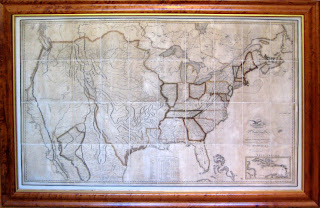
With American nationalism strengthening after the War of 1812, a friend mentioned to Melish that he would like to see a map that would condense one grand view of the whole of U.S. Territory. Recognizing the seemingly endless demand for geographical information on the American West, Melish produced his six-sheet map with the help of Philadelphia engravers John Vallance and Henry S. Tanner, which would later be known as his finest achievement. He drew on published eastern state maps and west coast surveys and city studies to create this mammoth sized map which is the first map to show the U.S. Territory stretching from the Atlantic to the Pacific. Little was know about the West, and this map seemed to embody the burgeoning notion of Manifest Destiny.
Although quite beautiful and magnificent to behold, this map functioned as a key in treaties and border disputes between the United States and Mexico in later years. It also improved knowledge of the American West and Texas, and thus promoted settlement in these areas by Anglo-Americans where opportunities for self-advancement and freedom seemed possible.
This map is currently on view at our Jackson Square location at 435 Jackson Street, San Francisco. Please contact us if you have any additional questions about this important map.
Monday, June 30 - Thursday, July 3rd - 10 a.m. to 5 p.m.Friday, July 4th - CLOSEDSaturday, July 5th - CLOSEDMonday, July 7th we will resume our regular schedule: Mon - Fri, 10 a.m. - 6 p.m.; Saturday 10 a.m. to 5 p.m.Happy Fourth of July!
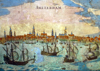 Detail of vignette of Amsterdam
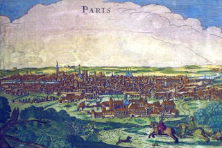 Detail of vignette of Paris
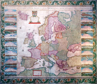
English cartography rose to prominence at the turn of the 18th century, and one of Britain’s most celebrated cartographers was Henry Overton, who successfully reissued several editions of John Speed's popular county maps of England. One of Overton’s most splendid productions is this wall map, a highly ornamental production that shows Europe as it was in the time of Louis XIV. The map is flanked by sixteen large detailed views of important cities: London, Paris, Rome, Amsterdam, Constantinople, Lisbon, Seville, Antwerp, Venice, Frankfurt, Prague, Cologne, Copenhagen, Kracow, and Danzig. This map is a valuable record of the growth of these cities, presenting an image of them as they were in the 1700’s. The whole is enclosed within a richly colored, highly decorative floral border.
This is a very rare map, not noted by the British Museum Catalogue of Printed Maps. The date of the map is uncertain, but is certainly after 1707, the year in which the mapmaker, Henry Overton, succeeded his father, John Overton. Antique wall maps such as this are exceedingly rare, for lacking the protection of bound maps, they were often destroyed by the effects of light, humidity, and carelessness. Overton’s Europe is a rare example of such a map to survive not only intact, but in excellent condition, with vivid original color.
This spectacular wall map is currently on view at Arader Galleries and available for purchase. For more information, call 415-788-5115.
 Andreas Cellarius
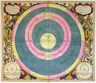 Andreas Cellarius
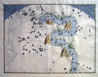 Johann Bayer
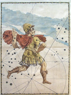 Johann Bayer
Bayer was a lawyer by trade and only an amateur astronomer. By publishing his atlas Bayer may have had an ulterior motive; he dedicated the atlas to the city council and prominent citizens of Augsburg who rewarded him with an honorarium and a seat on the city council as legal adviser. This atlas was created about 50 years after the "Peace of Augsburg," a treaty signed between Charles V, the holy roman emperor, and an alliance of Lutheran princes to end the struggle between the two groups. Bayer died near the beginning of the 30 years war in Germany .
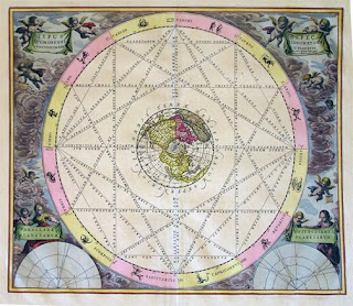
Andreas Cellarius, first released the Harmonia Macrocosmica in 1660 in Amsterdam , with a reprint in 1661. A post-humus edition was also produced in 1708 by Schenk and Valk (but without the Latin commentary). In general, the plates of the 1660/61 editions are coloured in bright tones – those of the 1708 reprint tend to be more plain in coloring. There were 29 color plates and the atlas was published by Johannas Janssonius as a cosmographical supplement to his Atlas Novis. Cellarius was a Dutch-German mathematician and cosmographer born in Neuhausen, Germany. At the time Harmonia was published he was also working as the rector (headmaster) of a Latin school. Cellarius started working on Harmonia shortly before 1647, and originally intended it to be a historical introduction for a two-volume treatise on cosmology but the second part was never published. In addition to their aesthetic appeal the plates represent the most sweeping and ambitious project in the history of celestial cartography. Harmonia illustrates the historical tensions of the times. It was first published in the same year that Freidrich Wilhelm “The Great Elector” gained sovernity over the Prussia, thus ending the Polish fiefdom.
The plates present the evolution of the field of astronomy from ancient times to hypotheses contemporary to Cellarius. They are executed in a distinctive visual language and portrayed the often-conflicting theories that prevailed. In addition to the relatively obscure notions of Tycho Brahe and Schiller, they also track the theories of Ptolemy and Copernicus. During the 17th and 18th century Dutch cartographers such as Cellarius reigned supreme in their field.
Images: Bayer: Cepheus. Eridanus (river) Cellarius: Typus Tuum, Opposi Ptolemaica Planetarum Eccentricos Demonstrans

 A highly educated merchant from Scotland, John Melish first visited America on business in 1806. He returned in 1811 to settle in Philadelphia and continue his successful business of commercial cartography where he quickly became one of America’s greatest mapmakers. Until the publication of this grand map of the United States, the growing body of geographical knowledge about America was assimilated primarily on military maps and British commercial maps, none of which had ever encompassed the entirety of U.S. Territory.